
Protecting and restoring native vegetation within Bremer River Catchment and Surrounds
The objective of this project was to support landholders in the Bremer River Catchment and surrounding areas to protect remnant vegetation and waterways and to support revegetation efforts. In total, 16 km of fencing were constructed and 10 ha of land re-vegetated across five farms.
Timeframe: December 2015 to December 2017
Funding source: State NRM
Project Coordinator: Georgina Griffiths
Summary
The objective of this project was to support landholders in the Bremer River Catchment and surrounding areas to protect remnant vegetation and waterways and to support revegetation efforts. In total, 16 km of fencing were constructed and 10 ha of land re-vegetated across five farms.
The FBG and landholders worked with Greening Australia to coordinate additional revegetation work at one other site. A revegetation guide for the area was updated and land management agreements were developed.
Project details and outcomes
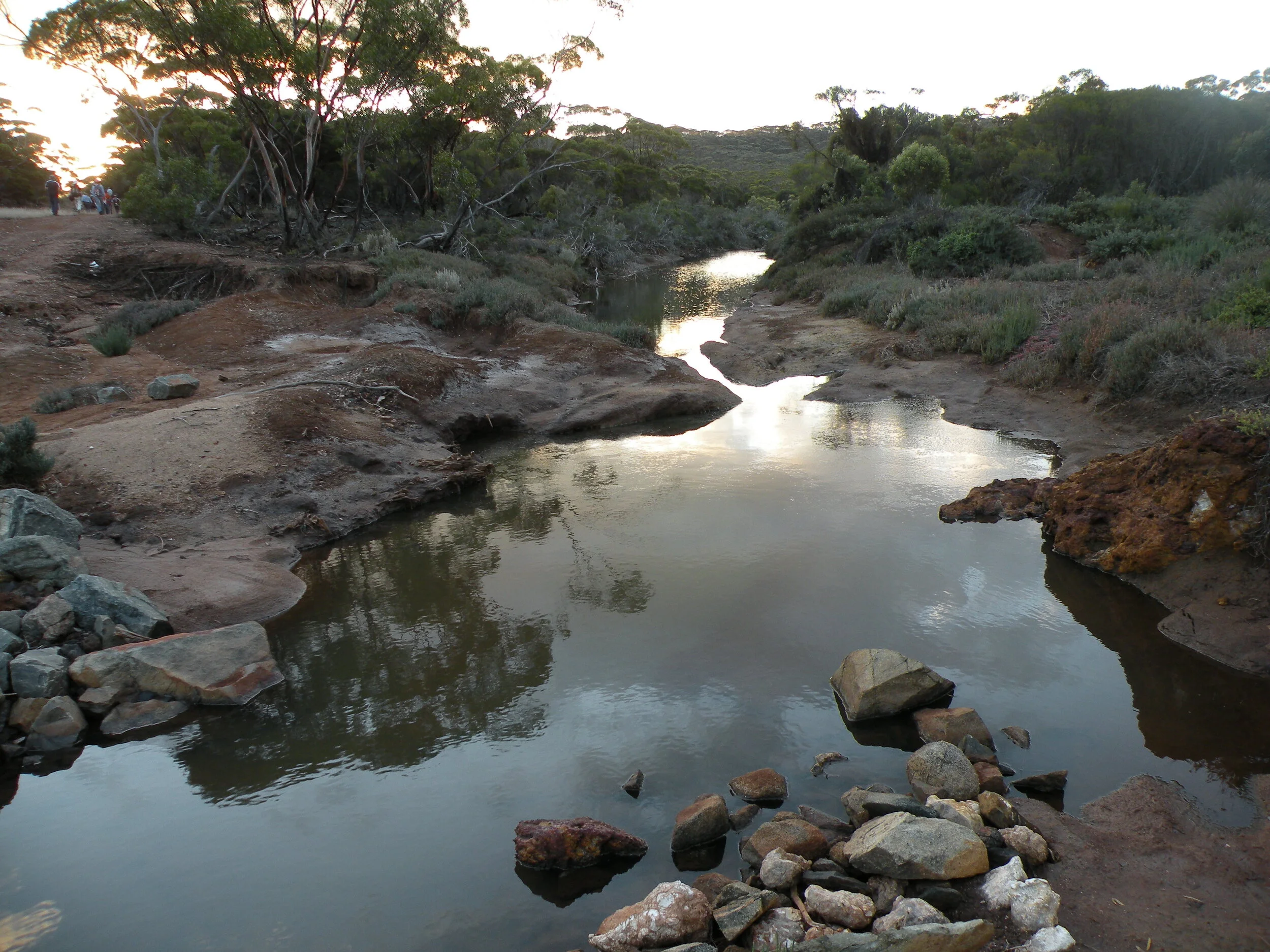
Three of the five sites in this project are located in the Devil's Creek catchment, which is a sub-catchment of the Bremer River. The site that included both fencing and 10 ha of revegetation had suffered from flood damage in the past and was salt affected and bare prior to revegetation. Three species of Eucalypt were planted on the least saline ground and Anameka saltbush was planted in the most salt affected areas. High rainfall in 2016 meant the site remained too wet to access so planting didn’t occur until 2017, at which time it was noted that there had also been natural recruitment of local salt tolerant species since the area had been fenced off.
The second fenced site, not far from the first, was subsequently revegetated through Greening Australia’s 20 Million Trees program. The third site is at the headwaters of the Devil’s Creek catchment so its protection has benefits for the catchment downstream.
The remaining two sites are wetlands located adjacent to the Bremer River Catchment. Each belongs to different, internally draining wetland systems fringed by Yate woodlands. The wetlands provide valuable habitat for a large range of woodland birds, waterbirds and native marsupials.
To support the on-ground works, the revegetation guide, Simple Systems for Revegetation and Native Forage in the Bremer River catchment guide by landscape ecologist Nathan McQuoid, was updated. This guide is a fit for purpose document to build knowledge and skills for best management practise in remedial Landcare practises.

Trialling dryland natural rubber production in the WA Wheatbelt
The main objectives of this project were to demonstrate whether or not Guayule rubber Parthenium argentatum could be produced in a dryland system in the WA Wheatbelt and to raise awareness of its potential as an alternative, sustainable cash crop for farmers in the region.
Timeframe: May 2016 to July 2017
Funding source: Agricultural Sciences Research and Development Fund, administered by the Western Australian Department of Primary Industries and Regional Development
Project Coordinator: Dr Henry Brockman, Department of Primary Industries and Regional Development, Albany.
FBG Support: Leonie McMahon
Summary
The main objectives of this project were to demonstrate whether or not Guayule rubber Parthenium argentatum could be produced in a dryland system in the WA Wheatbelt and to raise awareness of its potential as an alternative, sustainable cash crop for farmers in the region.
A three-hectare trial site was established in Gairdner on sandy-loam soils. A second site at Many Peaks was established and used as a nursery as well as a trial site. Combinations of direct seeding and seedling transplant were carried out during three separate seeding windows (May 2016, August to October 2016 and April to May 2017).
In each seeding window issues were experienced with low seed germination and establishment rates, and with high weed and insect burdens. The problems with seed viability and vigour were investigated in greenhouse trials, as was optimal soil temperature for germination. Drip irrigation was installed to assist with establishment at both trial sites. The issues could not be overcome in the available project timeframe and the decision was made in June 2017 to end the trial early.
Project details and outcomes
The main trial site located at Gairdner had three components: direct seeding, seedling transplant and control (irrigation). The second nursery site at Manypeaks was a sandy pasture paddock. Both sites were sprayed out several times to reduce the weed burden. Drip irrigation was established and about 500 greenhouse grown seedlings transplanted to the Many Peaks site.
The first direct seeding attempt occurred at the Gairdner site, later than ideal, in May 2016, when the soil temperature was between 10-12 degrees Celcius. No germination was observed. Subsequent experimentation with germination temperatures indicated that soil temperatures should be above 17 ⁰C for seed germination.
Three seeding attempts were carried out in August, September and October 2016 at the Many Peaks site. No germination was observed on the first two occasions and low germination occurred on the third. The final direct seeding attempt occurred in April to May 2017 at Gairdner. During the same period greenhouse germinated plants were transplanted to both sites, under irrigation. Germination and establishment were deemed too low to continue the trial.
The key issues experienced throughout the trial were:
An exceptionally extended wet and cold autumn, winter and early spring for the first season (2016).
Weed burden and insect attack (including wingless grasshoppers, weevils, snails) in spite of several regular herbicide and fungicide applications.
Low seed viability and vigour:
A fox chewing through driplines.
The following recommendations were made for future reference:
Trial management. The project manager should be in close proximity to the trial site to oversee and react quickly to emerging issues (such as those experienced with insect pests and weeds). The project manager needed dedicated assistance. Receipt of funding should occur well prior to optimal seeding times.
Site selection. Site selection is crucial – trial sites should to be part of a regular cropping rotation to prevent weed seed build up.
Irrigation. Supplementary irrigation for the first six weeks from seeding is most likely needed to enable successful germination and establishment (seeding end Feb/first week in March). The alternative is establishment through transplants.
Seed viability. In 2016, greenhouse germination rates showed only 30% of the seed was viable and that the vigour of germinating seedlings was poor. Higher germination rates (greater than 60%) and adequate seed quantities are required for successful dryland establishment. Producing locally adapted seed is thus of the utmost importance. Successful establishment of some plants at the irrigated site at Manypeaks will enable the production of seed for future trial work.
Agronomy. More work needs to be done on the overall agronomy of Guayule before further investigations into dryland production. For example, test results carried out during the trial indicated that soil temperatures should be above 17 ⁰C for seed germination.
Coated seed. The Guayule seed used for sowing in the trial was coated before import to Australia. Coated seed showed lower germination rates than when the coat was dissolved.
Improving feed value of perennial grasses
The overall objective of this project was to investigate different ways of improving feed value of perennial grasses in two different rainfall zones and at three different sites within the Jerramungup Shire.
Timeframe: January 2014 to December 2016
Funding source: Meat and Livestock Australia
Project Coordinator: Karryn Dorrell
Summary
The overall objective of this project was to investigate different ways of improving feed value of perennial grasses in two different rainfall zones and at three different sites within the Jerramungup Shire.
At Site 1 in the mid to low rainfall zone (450 – 350 mm) the aim was to trial a non-traditional perennial sub-tropical grass species (gatton panic). At Site 2 in the high rainfall zone (600-450 mm) the aim was to investigate methods of establishing annual pasture species into long-term kikuyu stands to increase the amount of winter feed generated. The aim at Site 3 (also in the high rainfall zone) was to investigate persistence, pasture yield and pasture quality by establishing legumes into a long-term kikuyu stand.
Overall, the trials highlighted that a combination of species selection, establishment methods and seasonal conditions determined success. Variability between soil types and rainfall zones necessitates locally-base trials.
Project details and outcomes
At the design stage of this project it was decided that no specialty machinery would be used so as to encourage other farmers to try establishing pasture on a paddock scale with existing equipment. Farmers in the trial were willing to make modifications to existing machinery where necessary.
SITE 1: trialling a non-traditional perennial sub-tropical grass species
Location: Brian and Janet Penna
Objectives;
To determine if seeding with a winter cover grass helps to establish Gatton Panic.
To determine if seeding with a soil wetter helps establish Gatton Panic better.
To determine if Gatton Panic could effectively extend the feed period and value of a pasture paddock over a three-year period in either quantity or quality.
Soil type: sand over gravel, consistent across the paddock and extremely prone to water repellence and wind erosion.
Seasonal conditions during establishment (2014): excellent
Results
A winter cover grass (barley) did help to establish Gatton Panic. The Panic grew at the base of each barley plant after it hayed off; the barley plant appearing to provide root and moisture channels.
A soil wetter did not have a significant impact on plant establishment however, the summer of the establishment year was a wet one and different results may occur in drier conditions. In the second year of the trial, the wetter-applied site had higher pasture production yields.
Gatton Panic raised both the quality and quantity of pasture production. It improved digestibility and energy marginally but the biggest gain was in the increased overall bulk yield compared with the annual pasture. It effectively extended the feed period and feed value of the pasture paddock throughout the trial.
SITE 2: investigating methods of establishing annual pasture species into long term kikuyu stands to increase the amount of winter feed generated.
Location: Ross and Rhonda Williams
Objectives:
To determine what seeding method provides the best establishment of alternative pastures into an eight-year-old Kikuyu stand.
To determine which pasture would establish better into kikuyu: oats or serradella.
To determine if a knockdown on the kikuyu followed by soil disturbance would create an environment that entices pre-existing clover in the seed bank to germinate.
Soil type: duplex sandy gravel
Seasonal conditions during establishment (2014): The year was characterised by a late break and a very dry summer.
Results
In both oat and Serradella sown pastures, knife points with double disk openers and press wheels provided the best seedling establishment by far. The wing points seemed to dry the soil out more and although they created an environment with less weed competition there was visibly less moisture in the soil.
Serradella pasture established a better stand than oats.
Soil disturbance did instigate growth of clover seed in the seed bank. The higher the tillage option the more the soil dried out, causing lower germination rates.
SITE 3: investigating persistence, pasture yield and pasture quality by establishing legumes into a long-term kikuyu stand.
Location: Ken and Jan, Paul and Alice Reddington
Objectives:
To determine which pasture species (bladder clover or serradella) is the most persistent species when sown into kikuyu.
To determine which pasture composition would give the highest feed quantity over the life of the trial.
To determine which pasture composition would give the highest feed value.
Soil type: duplex sandy gravel soil, chosen for its ten-year-old stand of kikuyu.
Results:
The most persistent pasture legume species sown into the kikuyu was bladder clover. It was slightly more persistent throughout the year whereas the serradella was predominant during winter months but less so during summer. Both legume species continued to emerge at very good rates in season two (2016) indicating the persistence was relatively good in both species, even though kikuyu was not suppressed in the second year.
The highest feed quantity over the life of the trial was the kikuyu pasture with no companion species. It produced between 1500kg-2000kg/ha higher yield during the summer months than the composite pastures and only 500kg/ha less, in one circumstance, than the composite pastures during winter.
Kikuyu pasture contained the highest quality of feed however, it was only marginally higher in digestible fibre, with little other feed value differences between compositions.

Frost management options to increase wheat grain quality and yield and how these strategies impact on soil erosion along the south coast of Western Australia
The objective of this project was to assess the suitability of stubble management options for minimising frost damage in cereal crops in a medium production environment, with consideration of secondary effects such as soil erosion.
Timeframe: 2015
Funding sources: GRDC, COGGO, DPIRD
Project Coordinator: Sally Carpenter
Summary
The objective of this project was to assess the suitability of stubble management options for minimising frost damage in cereal crops in a medium production environment, with consideration of secondary effects such as soil erosion. Stubble management options included retained stubble, reduced stubble and removed stubble. The impact of each treatment was measured extensively to identify any benefits of stubble management to frost mitigation.
The trial was held in Jacup at Stu and Leeanne Bee’s property. The site experienced 20 frost events at canopy level (temperature dropped below 0°C) between August and November. The severest event reached -3.5°C in a retained stubble during September.
Of the 20 recorded frost events, there was no event that showed significant differences between the three stubble treatments for either severity or duration. Consequently, the results did not conclusively support the use of stubble management as an effective frost management tool in medium production environments.
Project details and outcomes
Photo monitoring showed no negative impact of stubble removal on soil erosion. This was likely caused by the mild climate experienced in the early stages of crop development. Additionally, stubble removal was held off until immediately prior to seeding to minimise wind erosion.
Frost induced sterility/FIS (frost damage) varied from 5% to 14% across the site and no significant difference was found between stubble treatments. Previous studies suggest that the lack of significant variation could be due to the small difference in stubble loads and a difference may be observed in high production environments where stubble loads are greater.
All stubble treatments exhibited similar harvest index components, suggesting minimal difference in frost damage which corresponds with the other data collected.
Yields were low across the site and statistical analysis of the yield map data showed no differences between stubble treatments. This is expected as there were no temperature, FIS or harvest index differences between the treatments.
The results of the trial were inconclusive in supporting the use of stubble management as an effective frost management tool in medium production environments. Stubble management is a well-known practice, which has been increasing in recent years, particularly along the south coast of Western Australia. Results from this trial may result in a decline in unnecessary stubble management in these regions.
Action and Opportunities for Protecting Biodiversity Assets
This project was part of a much larger Dieback management project that operated across the state in four different regions. Its purpose was to implement a unified approach to landscape-scale management of Dieback in Western Australia. The activities focused on Priority Protection Areas (PPAs) that were rated of highest concern. The aspiration of the project was that no additional human vectored infestations would occur and the further spread of current infestations in PPAs would be limited.
Timeframe: July 2013 to June 2015
Funding source: State NRM (lead partner: South Coast NRM)
Staff: Anne Sparrow
Summary
This project was part of a much larger Dieback management project that operated across the state in four different regions. Its purpose was to implement a unified approach to landscape-scale management of Dieback in Western Australia. The activities focused on Priority Protection Areas (PPAs) that were rated of highest concern. The aspiration of the project was that no additional human vectored infestations would occur and the further spread of current infestations in PPAs would be limited.
The FBG’s work occurred mainly in the Fitzgerald Management Area which contains six PPAs. A rapid assessment process was carried out in this area to create a risk reduction plan. Four Dieback assessments were subsequently carried out in the Bremer Bay area to identify the presence or absence of the disease. Follow up on-ground work was taken as needed.
Activities to raise awareness about Dieback included 19 community events attended by 2026 people, the distribution of Dieback information through two different brochures, stubby holders, revegetation guides, articles in the FBG’s newsletter and in local newsletters in Bremer Bay and Jerramungup, posters, presentations to community and stalls at local market days.
Project details and outcomes
At the start of this project the Fitzgerald Biosphere Dieback Reference Group was formed to guide the compilation of the Fitzgerald Risk Reduction Plan. Representatives from the FBG, Ravensthorpe Agricultural Initiative Network (RAIN), Department of Parks and Wildlife (DPaW) and professionals with expertise in Dieback identification and management were included.
The Fitzgerald Management Area is located within the Fitzgerald Biosphere Reserve and covers approximately 300 000 ha, the majority of which is managed by DPaW. The remainder is vested in the shires of Jerramungup and Ravensthorpe or privately owned.
The Management Area contains six PPAs including:
Two which form the Fitzgerald East Complex comprising the Hamersley and Steere River/Culham Inlet catchments
Two which form the Fitzgerald Core Complex, encompassing Thumb Peak and Mid Mt Barren
One which forms the Fitzgerald West (North) PPA encompassing Fitzgerald, Gairdner on the eastern side of the Bremer River catchments
One which forms the Fitzgerald West (South) comprises the western side of the Bremer River catchment and Doubtful island area. This area was not merged with Fitzgerald West (north) for reasons including:
a near impossible network of roads and tracks to manage
the landscape values are equally represented in the Fitzgerald West (North) PPA
Infestations are present
The challenges of managing public access between the areas is seen as threat to the Fitzgerald Management area
The Fitzgerald Management Area contains two uninfested high value hotspots and four uninfested high value landscapes covering an area of 140 206.2 ha in total.
The FBG’s subgroups, Friends of Wellstead Estuary Plus (FOWEG+), and the Bremer Bay Regional Trails Committee, were partners in this project.
During the course of the project Dieback assessments were carried out at the Green Belt (a four hectare parcel of land in the townsite of Bremer Bay), the Carmichael Rd recreation and gravel reserve, the proposed path for the Bremer Bay to Point Henry walk trail and the Mary Street gravel pit in Bremer Bay. A further assessment was carried out at Chingarup private reserve in Boxwood Hill, where no Dieback was found.
Where Dieback species were identified in the other sites, management actions were carried out. Actions to mitigate against the Dieback infestation identified at the Green Belt in Bremer Bay included closing off vehicle access to the reserve and installing a boot cleaning station with associated signage. Any Dieback assessment carried out during the project was entered into the Dieback Information Delivery Management System (DIDMS). A boot cleaning station and Dieback signage were also installed at Quaalup Wilderness Retreat to lessen the risk of Dieback being introduced there.
An extensive community awareness program was carried out during the project. It included:
Six FBG newsletters: article on project activities and events
Two FBG calendars with Dieback focus: 2014 and 2015
Six adverts and articles in local papers and Jerramungup DHS school year book
Five Posters
20,000 Fitzgerald Biosphere brochures that included Dieback information distributed.
2,000 Dieback brochures distributed to visitor centres
1,000 Dieback stubby holders distributed
One case study on Ravensthorpe Enduro Club produced
300 Upper Gairdner Revegetation Guides with Dieback information included distributed
Two presentations; one at the Bremer Bay annual market day, the other at the Albany Dieback Forum
Green Card training
School visits and trips.
Protecting EPBC Species and Coastal Environments and Improving Soil Health
Timeframe: July 2013 – June 2015
Funding source: Caring for our Country (Federal funding devolved through South Coast NRM)
Project coordinators: Georgina Griffiths, Anne Sparrow
Summary
This over-arching project consisted of three sub-projects.
Sub-project 1: Protecting South Coast ecosystems: Recovery, threat abatement and connectivity actions for EPBC listed species.
This sub-project focused on the protection of habitat for Malleefowl and Carnabys Black Cockatoo on farming land. Activities consisted of fencing remnants, revegetating with native species and the publication of a local revegetation guide.
Subproject 2: Southern Soils – Best practice for sustainable soils in the South Coast of WA.
The focus of this sub-project was supporting farmers in the Jerramungup Shire to manage soil erosion. Activities included fencing of land vulnerable to wind and water erosion, the establishment of a demonstration site for fodder revegetation, production of a fact sheet using local sites where mitigation strategies had been employed and a range of workshops and field days.
Subproject 3: Restoring and Protecting Coastal Environments and Urban Waterways in the South Coast of WA.
The activities in this sub-project took place in Bremer Bay in an area known as the Green Belt, in collaboration with one of the FBG’s two subgroups: Friends of Wellstead Estuary Plus. Activities included monitoring of wildlife and feral animal activity using motion sensitive cameras, bird, vegetation and Dieback surveys, management of Victorian (Coastal) Tea Tree infestations, a range of community awareness programs, remnant fencing and revegetation.
Project details and outcomes
Sub-project 1: Protecting South Coast ecosystems: Recovery, threat abatement and connectivity actions for EPBC listed species.
Outputs:
Fourteen landholders completed 20 km of fencing, resulting in 591.4 ha of remnant vegetation being protected.
Two landholders planted 15 ha of revegetation to increase habitats and improve connectivity to remnant vegetation.
Publication of the Simple Systems for Revegetation and Native Forage in the Upper Gairdner River Catchment Guide (author: Nathan McQuoid).
Workshops included:
annual community fox shoots,
1080 accreditation courses
environmental awareness activities with the Jerramungup District High School.
Subproject 2: Southern Soils – Best practice for sustainable soils in the South Coast of WA. The focus of this project was supporting farmers in the Jerramungup Shire to manage soil erosion.
Outputs:
Seven landholders completed 20 ha of fencing, resulting in 200 ha of land being protected.
Sites on six properties were used to demonstrate successful protection of vulnerable soil from wind erosion through revegetation and the use of shelter belts. A fact sheet was produced to show how practice change had reduced soil and nutrient loss and wind and water erosion, and improved water quality on these properties.
A 35 ha site trialling native fodder revegetation as a means of managing marginal land that was susceptible to erosion was established.
Workshops included:
More Crop Less Weeds Sustainability Day at which the Australian Herbicide Resistance Initiative (AHRI) presented.
DIY Precision Ag Workshop for training on using mobile technology and precision agriculture for practical crop agronomy.
FBG Farmer Updates for cropping – 2014 and 2015
FBG Spring Field Days 2013 and 2014
Subsoil constraints workshop 2015 (which gave rise to the One Paddock Challenge concept)
FBG Ladies Day 2015 – Celebrating Women through Culture and Community
Subproject 3: Restoring and Protecting Coastal Environments and Urban Waterways in the South Coast of WA.
The FBG consulted with Friends of Wellstead Estuary Plus (FOWEG+) members to develop a strategic plan for the years 2013-2018 and to work out where the focus of their activities for this project should be. The area agreed on was a four-hectare parcel of unallocated crown land in the centre of the townsite known as the Greenbelt. A waterway that drains into the Wellstead Estuary runs through its centre. FOWEG+ partnered with the FBG and was an integral part of the project for its duration.
Outputs:
Fauna monitoring was carried out in the Green Belt, in wetlands behind the shire depot and along the estuary foreshore using motion-sensitive cameras. Images of foxes, feral cats, rats and rabbits were captured, but there were fewer images of native species.
Up to 73 bid species were recorded in the Green Belt from a series of surveys over a number of years. Bird activity is concentrated in the north western end of the reserve where vegetation is denser and human activity is minimal.
A survey of vegetation in the Green Belt identified 69 species ranging in condition from pristine to very good.
A program to completely eradicate Victorian (Coastal) Tea Tree from the Green Belt was successfully carried out.
A Dieback assessment in the Green Belt identified at least one affected area. The FBG worked with the Jerramungup Shire to reduce access to the reserve, improve the main path through the reserve, and better manage the introduction or removal of material to and from the Green Belt in order to prevent the spread of the disease.
Community engagement activities (spearheaded by FOWEG+) included:
Production of a community conservation brochure
Tidy Towns submissions in 2013 and 2014 (Winner of the Environment Category in 2013 and Waste Management and Litter Prevention Category in 2014, and host of the Regional Tidy Towns Awards in 2014)
Sandbar monitoring
Erection of temporary foreshore fencing to protect nesting shorebirds and rehabilitate sand dunes
Initiation of the No Butts campaign to promote environmental responsibility
Photo competition: What being in the Biosphere means to you
Environmental awareness raising at the Bremer Bay Primary School
Green Card training for Dieback hygiene
Signs about Dieback around the Green Belt
Wellstead Estuary Advisory Committee Review
Additional activities included:
Forty hectare of remnant vegetation protected on two private properties by the construction of 4 km of fencing.
Four hectares of revegetation using local species in an area that links a remnant and a swamp